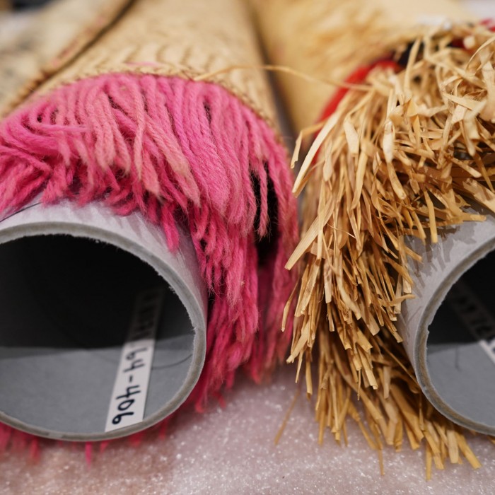
What Are Tapa and Woven Mats?
Learn about tapa

Faitau itulau ile gagana Samoa
With the development of the outrigger canoe around 5,000 years ago, groups of courageous individuals took to the seas to find new lands among the thousands of islands in Oceania. Far from a barrier, the ocean provided opportunity and connection.
The communities that settled on the islands shaped them into fertile grounds for prosperity, creating techniques for sustainable agriculture, some of which are still used today. They remained connected to a broader community through a series of networks to other islands and maintained family ties through trade and ceremonial gift exchange. When the European colonizers first explored the islands in the 1500s, they were met by hundreds of cultures that included master navigators, powerful chiefs, expert agriculturalists, and strongly bonded, vibrant communities.
This map does not represent or intend to represent official or legal boundaries of any Indigenous nations nor does it include the thousands of unique islands and hundreds of cultures in this region. The names featured represent most of the origin countries and territories of the tapa and woven mats mentioned in this exhibit.
While the first settlers of the Pacific Islands are thought to have crossed over land from northern Australia to New Guinea at least 40,000 years ago, evidence for human movement east of the Solomon Islands originates with groups of master seafarers in southern China approximately 5,000 years ago. Using the sun, stars, wind patterns, ocean currents, and bird flights to guide their outrigger canoes, these extraordinary voyagers brought with them domesticated plants and animals, allowing multiple generations to settle and thrive on the thousands of islands in Oceania.

Siapo, Samoa, collected around 1910. 57.8 x 47.3 in. NHM A.8371.64-340
The ocean and navigation are integral parts of Oceanic cultures, and these themes were depicted on tapa as well. This Samoan siapo dates to the early 1900s. Does this cloth look to have stars and waves patterns depicted on it?

Outrigger canoe model, Federated States of Micronesia, collected 1940s. 32.9 x 22.8 x 30.1 in. NHM A.9635.72-46
The outrigger canoe relies on a support float (or outrigger) attached to the main hull to provide stability. This image shows one type of outrigger, but other versions include canoes with support floats on each side, or two hulls lashed together with a center section for sitting. Finely woven mats were used as sails.

Fiji, 1890s. NHM A.5204.42-67 B
Outrigger canoe technology has remained virtually unchanged for thousands of years and continues to be used by Pacific Islanders and other seafaring cultures around the world. This image shows a crew on a Fijian camakau (single outrigger canoe).

Navigation chart, Marshall Islands, 1940s. 27.6 x 24.2 x 1.2 in. NHM A.9635.72-1
The master navigators that settled Oceania used the environment to guide their way. This Marshallese “stick chart," actually made from coconut fibers and cowrie shells, shows the patterns of the wind and waves, as well as neighboring islands represented by the shells. These charts would not have been taken on a voyage, but memorized by the navigator prior to departure.
Understanding how to live within and transform their environment to support the needs of their communities was key to developing the thriving cultures of the Pacific Islands. From mastery of the sea and marine resources when many islands were first inhabited to development of agricultural practices, each community expertly adapted their unique island landscapes to support their societies.

Photo: Ashay vb, 2019. Wikicommons. CC BY-SA 4.0
Some of the Pacific Islands were more biologically diverse than others. Early settlers relied on native marine resources and wild animals, but also on imported cultivated plants such as taro, yam, breadfruit, bananas, and coconuts, which soon produced necessary dietary staples.

Master navigator Mau Piilug (Satawal Atoll, Yap State) and Steve Thomas study the sky, 1983. Photo: Steve Thomas. UHM Library Digital Collections
Mastery of individual Pacific Island landscapes and ecosystems supported the development of unique cultures and encouraged contact between island communities. The result is a long history of communication and connection between different Pacific Island groups.

Photo: Molly Des Jardin, 2010
Pacific Island societies changed their landscapes and developed various systems for growing cultivars. Irrigated pondfields, dryland fields, yam mounds, and non-irrigated terraces all supported growing populations.

Taro patch, Yap, Federated States of Micronesia. Photo: Amy Gusick, 2018
This wetland taro patch on the island of Yap has been passed down and maintained for generations. Taro patches also played a role in tapa design—several cultures used the patches to immersion dye pieces of barkcloth dark brown or black.

Siapo, Pago Pago, Samoa (now American Samoa), collected in 1935. 35.2 x 35.2 in. NHM A.10768.82-5
Images from nature are common on tapa and represent the deep connection that many societies have with their surrounding environment. These environmental depictions can be abstract to outsiders, but are recognizable to the individual Pacific Island communities. This Samoan siapo, for example, appears to have representations of plants.

Photo taken by Expedition 18 crew, International Space Station, 2009. NASA ISS018-E-18129
The environment remains an important issue for Pacific Island communities. Islands like Atafu Atoll, Tokelau, are experiencing the impact of increasing drought, coastal flooding, erosion, and sea-level change. The elevation of Atafu is only six-and-a-half feet above water level, making long-term habitability uncertain. To help understand these effects, many Pacific Island nations belong to the United Nations' Small Island Developing States (SIDS) group, which looks for sustainable ways to support its members.
Many early Pacific Island cultures were hierarchical, with a chief as leader. When the Europeans first encountered the islands in Oceania in the 1500s, they often refused (or failed) to recognize these social structures, thus beginning centuries of intrusion into lands and cultures that had been thriving for thousands of years. As European and American government officials, military forces, missionaries, merchants, medical workers, company employees, and other visitors continued their incursion into the area, they forever changed the region.
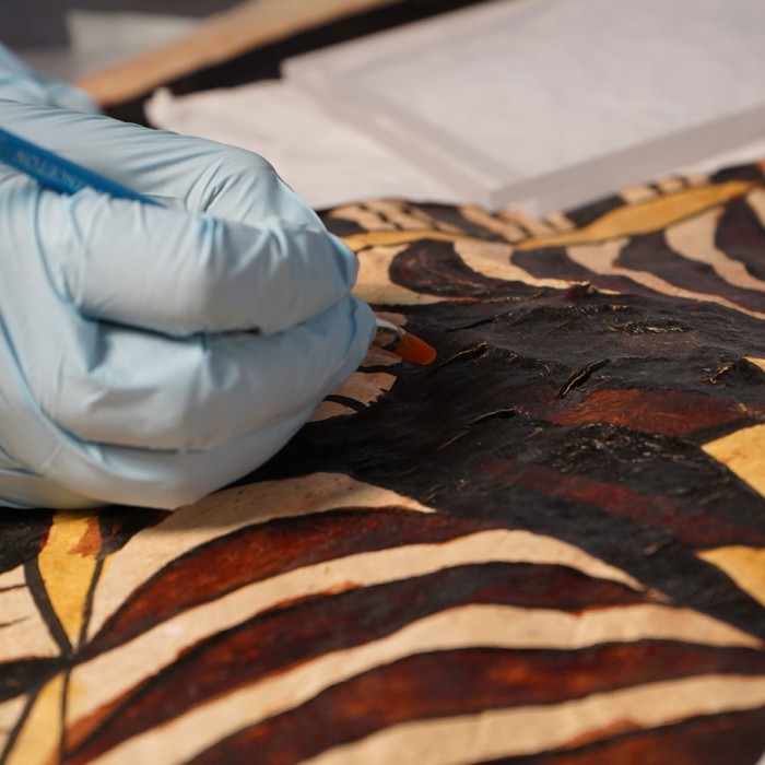
The tapa and woven mat collection at NHMLAC is part of this history. From soldiers and medical workers to employees of companies engaging in resource extraction, many visitors collected cultural material from the local communities. Much of this material was donated to American and European museums—including NHMLAC—creating vast collections rooted in colonialism and developed with an outsider’s perspective on the culture.

Jacques Nicolas Bellin, “Répresentation du cours ordinaire des vents de traverse qui regnent sur les côtes dans la grande Mer du Sud” (1753). Probably issued in Abbé Prévost’s Histoire générale des voyages . . . (Paris, 1746–70). Historic Maps Collect
As colonial powers in Europe, the United States, and Asia recognized the strategic usefulness of the Pacific Islands for diplomacy and for replenishing supplies on their trade routes, they began to set up bases of operations on some islands, bringing with them entirely different cultures, as well as conflict, war, and disease.

Siapo, Samoa, collected around 1909. 33.5 x 32.5 in. NHM A.8371.64-338
France, Germany, Britain, Spain, Netherlands, Portugal, the United States, and Japan all claimed ownership of one or more Pacific islands starting in the 1800s, with some continuing through to today. This Samoan siapo has a representation of the US flag on it and was likely created shortly after 1899, when Germany, Britain, and the United States partitioned Samoa into German Samoa (now the Independent State of Samoa) and American Samoa, which remains unincorporated.

The surrender of the German fleet, photographer unknown, Harwich, UK, 1918. © IWM Q 20616
World War I and World War II greatly impacted the Pacific Islands. At the end of WWII, foreign powers kept the islands they had occupied during the war. By claiming to be helping the Pacific peoples adapt to the modern world, countries like Germany, Japan, and the United States introduced foreign cultural belief systems to many island nations.

Navy nurses give a yaws injection to a child on Ulithi Atoll in the Federated States of Micronesia, 1945. Photo: U.S. Navy. UHM Library Digital Collections
Along with new belief systems, colonial powers also brought disease like measles and influenza. The 1875 measles epidemic killed 33% of the population of Fiji and the 1918 flu epidemic killed between 4% and 22% percent of the populations of Fiji, Tonga, Guam, Tahiti, and Samoa.

Siapo, Samoa, collected around 1909. 51.4 x 47.4 in. NHM A.8371.64-355
Many of the tapa at NHM were donated by military doctors that were in the region to care for American soldiers. These doctors also assisted local populations during outbreaks of foreign diseases brought by outsiders. The Samoan siapo pictured here was donated by Admiral Rossiter, the 18th Surgeon General of the Navy, who served in Samoa in the early 1900s.

Bikini Atoll relocation. Photographer unknown, Marshall Islands, 1946, NHM A.5564.46-58.1
Between 1946 and 1958, the United States detonated 67 nuclear bombs on and around Bikini Atoll in the Marshall Islands. Prior to the bombing, the US military moved the inhabitants of the atoll to Rongerik Atoll, an uninhabitable island that the Bikinians believed to be occupied by evil spirits.

Bikini Atoll relocation. Photographer unknown, Marshall Islands, 1946, NHM A.5564.46-58.5
After two years of near starvation, the Bikinian people were moved to Kwajalein Atoll, and then to Kili Island. Today, Bikini Atoll remains uninhabitable due to high levels of radiation.

Coconut grater and bowl, Bikini Atoll, Marshall Islands, collected 1946. Left: 33.5 x 9.5 x 10.8 in. NHM A.5564.46-16 Right: 5.0 x 5.0 x 5.0 in. NHM A.5564.46-27
Part of the cultural material at the Museum comes from the terrible destruction of the Bikinian’s home. Commander Harold W. Grieve was in charge of the Navy Reserves sent to relocate the Bikinians. Grieve donated tapa and other items, like the coconut grater and coconut bowl pictured here. He also donated numerous photographs documenting the relocation of the Bikinians to Rongerik Atoll.

Photographer unknown, Nauru, 2014
The history of colonialism in Oceania is also one of resource exploitation. For example, phosphate mining on Nauru devastated the island, leaving a landscape filled with coral pillars, as well as a weakened marine ecosystem from the silt and phosphate runoff.

Purse and brush, Nauru, collected around 1920. Left: 11.8 x 3.7 x 6.3 in. NHM A.5772.47-14 Right: 8.9 x 1.2 in. NHM A.5772.47-7
Among the donors to the Pacific Island collection at NHM are individuals who worked as contractors or doctors for the foreign companies that extracted phosphate, oil, and other resources in the Pacific Islands. This purse and a brush used to apply coconut oil onto a young infant were collected by medical professionals who worked for the Pacific Phosphate Mining Co. on Nauru.
[Tapa and woven mats] are used as a marker of cultural identity, and are significant because if one can’t be in their own culture and living it daily, then having these tangible markers present are all the more important. They take on new meaning for those in diasporic communities.
—Katrina Talei Igglesden (Fijian)
Today, there are large populations of people with shared Pacific Islands cultural heritage or homelands that live all over the world. Called diasporic communities, there are especially large groups in Aotearoa (New Zealand), Australia, and the United States. California is home to almost 25% of the 1.2 million Kanaka Maoli (Native Hawaiians) and Pacific Islanders currently living in the United States. These communities retain strong bonds to their homelands, preserving their identity by continuing cultural traditions like gifting tapa and woven mats. While each group has its own culture, there are commonalities among them, including the importance of tapa and finely woven mats, which can be found among many diasporic Pacific Island households.

Ngatu, Tonga, collected around 1954. 152.0 x 75.6 in. NHM F.A.2725.87-1
In Tonga, it has been common practice to use ngatu as sleeping mats. This tradition was carried on by the family that owned this Tongan ngatu after they moved to the United States in the mid-1900s.

Photo courtesy Asena Taione-Filihia
Tapa and finely woven mats are an important part of many Pacific Islander milestone ceremonies, both in and outside the region. This image, taken in Southern California, shows attendees at a Tongan women’s 21st birthday celebration wearing ngatu and finely woven mats.

Photo courtesy Asena Taione-Filihia
Outside of Hawai'i, the greater Los Angeles area has the largest Pacific Island diasporic population within the United States. To support this community, there are numerous organizations within the region. This image shows a community event by MALO (Motivating Action Leadership Opportunity), a nonprofit that serves Tongan Americans in the Inland Empire area through youth mentorship, job readiness, resource literacy, and cultural gathering events.

Photo courtesy Tafesilafa'i Pacific Islander Festival
The Tafesilafa'i Pacific Islander Festival, held in Long Beach, is a festival for Pacific Islanders to come together and exchange stories, ideas, and resources. These celebrations showcase the various cultural traditions and diversity of Pacific Island communities in California. They also provide Southern California–based Pacific Islander organizations with opportunities to reach a broader audience.

A Tongan ngatu-making workshop. Photo courtesy Asena Taione-Filihia
Many Pacific Islander organizations offer education as one of their core services. Alongside classes about health initiatives, citizenship, job training, etc., many organizations also offer workshops aimed at preserving cultural heritage, including tapa making.
The Natural History Museums of Los Angeles County wish to thank the following community members for their support with this project: Audrey Alo, Cindi Alvitre, Juliann Anesi, Katrina Talei Igglesden, Fran Lujan, Kirisitina Sailiata, Tavae Samuelu, Kelani Silk, Lolofi Soakai, Asena Taione-Filihia, and Craig Torres. The Fabric of Community has been made possible in part by a major grant from the National Endowment for the Humanities (NEH): Democracy demands wisdom. Any views, findings, conclusions, or recommendations expressed in this exhibition do not necessarily represent those of the NEH.